Newton Abbot is the biggest town within the Teign catchment area, with a population of about 25,000. The centre of modern Newton Abbot is situated astride the River Lemon, or what remains of it – part of the river was built over as long ago as the 1870s when a new market and other public buildings were constructed, and either side of the covered-in section the river now flows through a deep concrete channel, as a protection against flooding.
 The Alexandra Cinema in Market Street. (February 2012) The plaque on the tower shows the date of its construction: 1871, when this area was rebuilt leaving the River Lemon underground. It was originally a concert and banqueting hall, later a theatre, before it became a cinema. It is thought that the Italianate tower was influenced by the design of the pumping stations for the ill-fated atmospheric railway.
Thus as far as Newton Abbot is concerned the Lemon has changed from an asset, that used to provide water for industrial and domestic use and power for various mills, to a liability. However, no doubt the river water is a lot cleaner now than it was when factories and houses were discharging their wastes into it.
 River Lemon in its narrow channel at Victoria Place (March 2010)
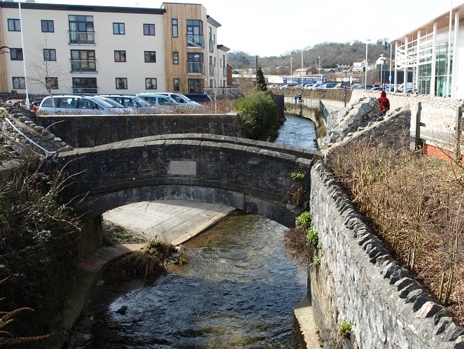 Union Bridge (March 2010). This small footbridge over the Lemon was built in 1822. It was located on the site of a ford, and funded by public subscription. Its name presumably refers to the fact that it was a link between two townships, Newton Abbot and Newton Bushel, which were still administered separately at that time.
It would be nice to think that the Lemon was named when the climate was warm enough for citrus fruit to be grown in its valley, but while that isn’t the case, no-one seems certain about the origin of the name. Like most names of geographic features it has been variously represented in the past on documents and maps– Lymen, Leman, Limene, etc, and it could be a derivation of the Celtic word meaning ‘elm’ – which suggests that elms grew along its banks. Elm trees used to be common before Dutch Elm Disease struck in the 1970s – sadly by 1990 very few mature elms were left in Britain.
The Lemon is a tributary of the Teign, and the section of the Teign just upstream of the estuary forms a natural boundary separating Newton Abbot from Kingsteignton.
During the 1940s and 1950s the Alexandra was one of four cinemas in Newton Abbot, the others being the Empire Picture House in Lemon Road, the Imperial Electric Cinema in Queen St, and the Odeon just off Wolborough Street. The Alexandra was showing films as early as 1909, but not continuously until 1927 when a balcony and projection room were installed. The first films shown when it re-opened as a full-time cinema were Prisoners of the Storm and The Cheerful Fraud, both made in 1926. Of course this was still the ‘silent’ movie era, and it’s remarkable how few leading actors of the ‘silent’ era continued working once sound took over between 1928 and 1930, and consequently are now completely forgotten. The leads in Prisoners of the Storm were House Peters (yes, his name really was ‘House’), who appeared in over 50 films from 1913 to 1928, and Peggy Montgomery, who made 30 films from 1924 to 1929. The Cheerful Fraud starred Reginald Denny and Gertrude Olmstead. Olmstead appeared in 41 films from 1921 to 1929, when she retired at the age of 25.
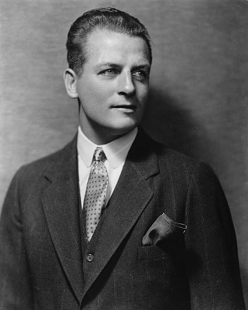
Reginald Denny in his prime.
Reginald Denny was the exception. He was born in Surrey, made his first British film in 1912, then moved to America and made his debut there in 1915, and subsequently moved back there after service as an airman in the Great War. He made around 60 silent films, many of them ‘shorts’, before successfully making the transition to sound in 1929. His acting ability and pleasant English-accented voice with crystal-clear diction enabled him to sustain a career in supporting and character parts and he appeared in over 100 more films after 1929, and towards the end of his career he also made regular appearances in TV series and dramas. In parallel with his acting career Denny became interested in model plane building and by the time of World War II this developed into a business called Radioplane, making radio-controlled target drones for the US Army. Near the end of the war a publicity photo shoot took place at the plant where a pretty young employee became a magnet for the photographers. This encouraged her to seek work as a model, which later led to her being noticed by a film studio executive and in 1946, aged 19, she was offered a studio contract. Her name was Norma Jeane Dougherty née Mortenson, whose screen name became Marilyn Monroe.
The Imperial cinema was in operation from 1913 to 1962. Its façade can still be seen at the junction of Queen Street and Lemon Road.
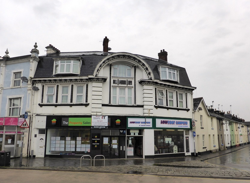 Imperial Cinema facade, Queen Street (April 2014)
There is now no trace of the other two cinemas.
One noticeable feature of Newton Abbot are the hills that overlook the town centre, particularly Knowles Hill and Wolborough Hill. Knowles Hill is higher than the surrounding land because the upper and middle sections are made of an erosion-resistant igneous rock called dolerite, which welled up between rock strata many millions of years ago. There used to be a quarry on the hill and its products can be seen in various places.
 Dolerite blocks in a wall on Knowles Hill.
 Looking south from Knowles Hill over the town centre towards Wolborough Hill (February 2012)
The surrounding hills also contain two prehistoric sites. Berry’s Wood Hill Fort near Bradley Manor is a contour hill fort of Neolithic origin enclosing an area of 11 acres. There is a legend that men in armour are to be seen lying there on moonlight nights. Excavations in the 1930s at Milber Down Camp on the SE outskirts of the town revealed that it was built in the 1st century BC. Unfortunately little remains above ground, the site is bisected by a busy minor road, and an abbatoir has been built within the site.
There is increasing evidence of Romano-British settlement in the Newton Abbot area. For example, quite recently a metal detectorist found 100 Roman coins scattered over two fields east of Ipplepen, and this has prompted excavations that so far have produced finds from the Neolithic to medieval periods, and indications that the site was farmed in Roman times.
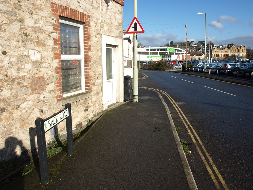 Back Road today – a cul-de-sac that leads only to the Asda supermarket car park.
It is generally accepted that there was a bridge over the Teign during the Roman period at Teign Bridge and, although no trace has yet been found, it is logical that a Roman road continued on to cross the Lemon and, if so, probably used the line of the present Back Road. If there was a crossing point here it is likely that a settlement of some kind existed much earlier than once thought likely.
The arrival of the railway in 1846 changed Newton Abbot from a small, sleepy market town with wool and leather trades to a bustling place with new industry that brought in many new residents. At the beginning of the 19th century the population of the town was 1,600, by the end of the century it had risen to 12,500. From the 1870s the Great Western Railway ran a repair and maintenance operation, the largest in the West Country. It continued to grow so that by 1930 over 1,000 people worked there, and nearly 2,000 in the 1950s. But after that, as steam engines were withdrawn and new depots set up elsewhere, it gradually reduced in size, so that by 1990 only 50 employees were left. The site is now occupied by the Brunel Industrial Estate. There was also a large goods marshalling yard at Hackney. Other industries that serviced or used the railways were set up near the station, including engineering works, a timber yard, iron and brass foundries, and a grain and cider depot and maltings. Terraced streets were built to house the workers.
 Terraced houses climbing Lea Mount Road, off East Street (February 2012)
… and attractively styled villas for the factory owners and wealthier professionals also sprang up on the elevated land on Knowles and Wolborough Hills, and in Devon Square and Courtenay Park Road on land owned by the Earl of Devon.

 Villas in Devon Square (February 2012)
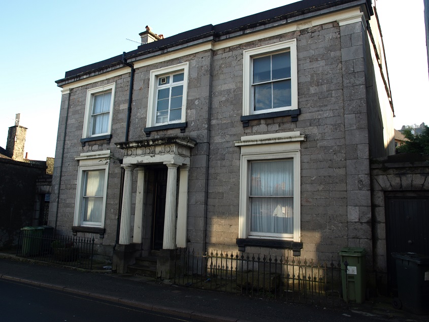
 Minerva House in Highweek Street, once owned by Mr John Balle Pinsent, proprietor of Pinsent’s Brewery. (February 2012) Prior to Mr Pinsent it was occupied by a Dr Green who sold his own brand of ‘Celebrated Royal Antiscorbutic Drops’ – a preventative against scurvy, a vitamin defiency common among seafarers at the time.
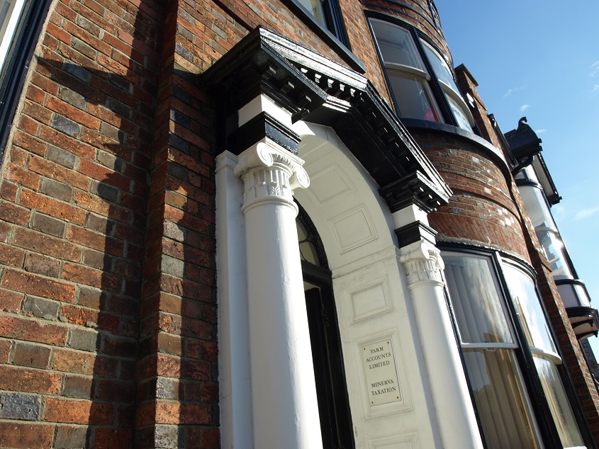 Detail of doorway in Minerva House (January 2014)
The house used to have a large garden famed for its beauty, with a lake fed by a water channel off the Mill Leat. It was bought by the Council in 1936; the house is now offices and the garden is the site of the livestock market.
 A corner of the livestock market. (February 2012) The back of Minerva House is just to the right of the market roof.
Until the 1840s the built-up area was mainly centred on East Street, Wolborough Street, Highweek Street and Market Street – alongside the Lemon, but far enough upstream to not be affected by tidal variations in river level, with the risk of flooding.
The land below Hero Bridge was marshy and liable to flooding (below this point the aptly named Marsh Road runs along the banks of the river).
 The River Lemon next to Marsh Road (March 2010)
The central part of the town has been badly flooded from time to time, the last serious such event being in 1979, when more than 700 properties were affected. After that the river banks were strengthened and raised, and the Lemon was dammed at Holbeam as part of a flood prevention scheme, amusingly titled ‘Squeezing the Lemon’. Up to 90 million gallons of water can be held behind the dam. After torrential rain on December 24th 2013 the water level rose by 9m and as a result the dam was overtopped for the first time since it was built in 1982, although nothing serious resulted downstream. The flow of water from the dam is matched to the capacity of the river channel through Newton Abbot, but climate change predictions suggest a 10% increase in flow by 2025, and more beyond that. The culverted section under the town centre is a potential bottleneck with finite capacity, and it is reported that consideration is being given to opening up the river again as part of a town centre re-modelling scheme, which would enable the flow capacity to be increased, as well as providing a civic amenity.
 Commercial buildings on Bradley Lane, next to the River Lemon (March 2010)
The Lemon originates in two streams that rise just north and south of Haytor Rocks, on the eastern edge of Dartmoor.
Haytor is one of the most visited spots on Dartmoor, due to its proximity to the road from Bovey Tracey to Widecombe, and the easy walk up to the rocks, which reach a height of 1,499 feet above sea level. The granite between the two main outcrops has been eroded away, leaving an ‘avenue’ between.

Part of the 1953 MGM film Knights of the Round Table was shot around Haytor. It is recorded that a Camelot Castle set was built between the two main rock piles of the tor, although this isn’t apparent in the scenes set in the castle. Haytor Rocks and one end of the castle wall are seen briefly towards the beginning of the film (see above), otherwise the only recognisable location in the film is the valley leading down to the ruins of Tintagel Castle, on the north coast of Cornwall, which is the scene of a battle set in Scotland between local Picts and a conquering army commanded by Sir Lancelot. (Although Knights was the first widescreen colour feature made by MGM, and therefore something of a prestige project, this is not a film that is worth seeking out – it is overlong and rather monotonous, most of the acting is wooden, and the dialogue stilted. The best things in it are the costumes, particularly for the horses, and Stanley Baker as the baddie Mordred, who has it in for King Arthur and Sir Lancelot.)
 The characteristic shape of the rocks is a notable landmark visible on the skyline from many places between Exeter and Totnes. (January 2012) In good visibility, there are excellent views of the coastline, the Teign Estuary and the rolling countryside between, with the ridge of Haldon behind.
The Lemon has a fairly direct route from Haytor down to where it meets the Teign just above Newton Abbot quay. Consequently it is relatively fast flowing, and in the past has powered several mills placed along its banks. We tend to think that water mills were used to grind grain to make flour, and in many cases that was their original purpose, but from the 19th century they were used to drive other processes. Chipley Mill was used to grind bones for fertiliser.
[ photo to come]
And at Holbeam Mill fish hooks, fishermen’s knives, anchors, and miscellaneous ironware were manufactured, and finally agricultural implements, until it closed in 1943. Today it survives as a private house. When it closed the machinery was acquired by the Science Museum.
[ photo to come]
A bit further downstream the Lemon flows through a hilly wooded area past Bradley Manor.
 The path on the lower slopes of Emblett Hill, on the south side of the River Lemon (September 2012)
The manor house is situated in a secluded woodland position and its exact location was almost certainly determined by a constantly flowing spring nearby, now known as the Wishing Well, adjacent to the bridge on the footpath to the house. Its water supposedly has curative properties, especially for eye troubles. The origins of the house go back to the thirteenth century, and there are still several sections of the structure visible from this period. In the late fourteenth century it was the mansion house of the borough of Teignwick. Then in the early fifteenth century its owners built a new house joined on to the old one and at right angles to it. The property has undergone many changes during the following 600 years, without destroying its essentially medieval character. It has never been owned by any titled person with great wealth – if it had, it would probably have been knocked down in the 17th or 18th century, and a completely new much grander house built in its place. In 1938 Bradley Manor, together with its 70 acres of woods and meadows along the Lemon valley, was given to the National Trust, and this has had the effect of protecting a valuable area of natural beauty and recreational value close to the centre of Newton Abbot, which otherwise would almost certainly have been built on by now. The house is still occupied by members of the family who gave it to the National Trust, and contains a collection of Pre-Raphaelite art and Arts and Crafts furniture.
 The woods of Bradley Vale, seen from Wolborough Hill (September 2012)
 The eastern facade of Bradley Manor House (September 2012)
 One of the terminal carvings on the dripstones of the ground floor windows. Apparently there are four carvings that represent the symbolic winged creatures of the four Evangelists, and this one is St Matthew the man – the others being St Mark the lion, St John the eagle, and St Luke the bull calf.
The Lemon feeds a leat leading to Bradley Mills, at the head of Bradley Lane. Here the river water was used in cleansing and dying processes associated with woollen and leather works, and also as a source of energy. The Mill Leat also used to power a flour mill in the centre of the town, on the site of the cattle market. The Lemon was heavily utilised in earlier times: it is recorded that Gilbert Yarde, who inherited Bradley Manor in 1467, had three fulling mills for washing wool and well as three corn mills.
 The Mill Leat in Bradley Woods (September 2012)
 The sluice gate at the beginning of the Mill Leat (September 2012)
In the woodland close to Bradley Manor there is a natural steep-sided hollow (probably a collapsed limestone cavern) accessible via a steep path on the south side of the river, but invisible from both the river and the main path through the woods. It is known as Puritan’s Pit because from the early 1660s Non-Conformists held meetings of worship there at night in order to keep them secret, and thereby avoid persecution.
 Puritan’s Pit (September 2012) This feature is difficult to photograph – a deep hole in the ground surrounded by big trees, and strong sunlight doesn’t help. Among the foliage and shadows you can just make out the steep sides of limestone rock.
The story goes that Willam Yeo, a very strict Presbyterian clergyman who had been installed as Rector of Wolborough in 1648 by Oliver Cromwell, was (along with 2000 other clergymen across the country) deprived of his living in 1662 for refusing to acknowledge the so-called Act of Uniformity, which brought back many rites and ceremonies abolished by the Puritans during the Civil War, in particular the compulsory use of the Book of Common Prayer in religious services. The outlawing of dissenting ministers -at one time monetary rewards were offered for their apprehension – was only stopped in 1689 by the Act of Toleration.
In 2014 the urban area of Newton Abbot began to be extended westwards along the A383 around Hele Park. Just beyond this new housing lies Seale-Hayne, which when built just before the First World War was the only purpose-built agricultural college in the UK.
The front of the original Seale-Hayne college building (September 2015).
It is named after Charles Seale-Hayne, a local politician and land-owner whose legacy funded its construction. In the 1980s it had over 1,000 students, but later became part of Plymouth University which in 2005 closed the college and transferred the staff and students to Plymouth. Today it is used by the Dame Hannah Rogers Trust, which provides education, therapy, care and respite for children and young people with profound physical disabilities and hosts events in order to raise funds for the Trust’s school in Ivybridge.
The college is built on four sides of a large inner courtyard. (September 2015) The decorated pigs may have been the work of one of the artists with workshops on the site.
Upstream from Holbeam Mill the Lemon flows through the lower part of Bickington village.
 The River Lemon at Bickington (May 2012)
At the top end of Bickington the tower of the church dedicated to St Mary The Virgin is a prominent landmark. The church is 15th century in origin, with a major restoration in the 1880s. It has a unusual lychgate with a room built over it.
 The lychgate in front of Bickington church (May 2012). The room over was built relatively recently, in 1901. The structure incoporates a wooden arch from the early or mid 16th century. The plaque on the front wall records the arrival of the mains water supply to the village in 1962.
North and north west of Bickington there is an attractive area of hilly land bordering Dartmoor, drained by the Lemon and the Liverton Brook (which is actually a tributary of the Teign). There are woods in the valleys and grazing on higher ground, and four villages – Haytor Vale, Ilsington, Liverton and Sigford. These villages and other smaller settlements are linked by the usual complicated network of narrow lanes with high Devon banks and hedges, as here near Sigford. Note the water running off the field onto the road – the whole of rural SW England was completely waterlogged throughout December 2012 due to exceptionally heavy rainfall.
 Gateway and lane above Lower Sigford Farm (December 2012)
 The Rock Inn, Haytor Vale (December 2012)
 Ilsington: cottages and the lych gate at the entrance to St Michael’s church (December 2012). The figure to the right of the room over the lych gate is St George, part of the parish war memorial for the 1914-18 conflict. An information board inside the lych gate reports that in 1639 the whole structure, including a school room situated over the gate, suddenly collapsed so that the roof fell in on the 17 boys and a master inside. Fortunately no-one was killed.
 Bridge over the Liverton Brook just west of Liverton village. (December 2012)
A mile or so upstream from Liverton, the brook flows under a bridge on the road down from Brimley, opposite Ilsington Wood.
There was very little water in the brook when this photo was taken (in August 2013)
 A meeting of narrow roads near Bickington Barton (May 2012)
Moving back to Newton Abbot ….. in Norman times there was a motte and bailey castle on Highweek Hill, which perhaps served the dual purpose of a refuge from unfriendly natives and a lookout post to watch for people coming up the Teign Estuary. The site of the castle has now been buried under houses and gardens. A village which used to be known as Teignweek grew up around this castle; in the 13th century it became Highweek (meaning ‘village on high ground’) to distinguish it from another settlement on low ground by the river Lemon, which became part of Wolborough Manor.
 All Saints church, Highweek, on the top of Highweek Hill (September 2012). It was built in 1428, and was originally a chapel-of-ease to its mother church, St Michael’s, Kingsteignton, so had no burial ground and the dead had to be carried to there to be buried via the Church Path.
Teignweek’s owner, the interestingly named Theobald de Englishville, left his manor to his nephew Robert Bushel, who then left it to his son, and so on. By the 14th century the two communities either side of the River Lemon were known as Newton Abbott (the New Town of the Abbots) and Newton Bushel, after their respective owners. The two parts of the town continued to be known by these names until the end of the 19th century.
Highweek Road was once one of the main roads to and from the town centre. This attractive early 19th century house (actually a pair of semis) has a sign indicating that this is the route to Ashburton, of a size and height designed for horse-drawn coaches and horse riders passing by far more slowly than today’s traffic.
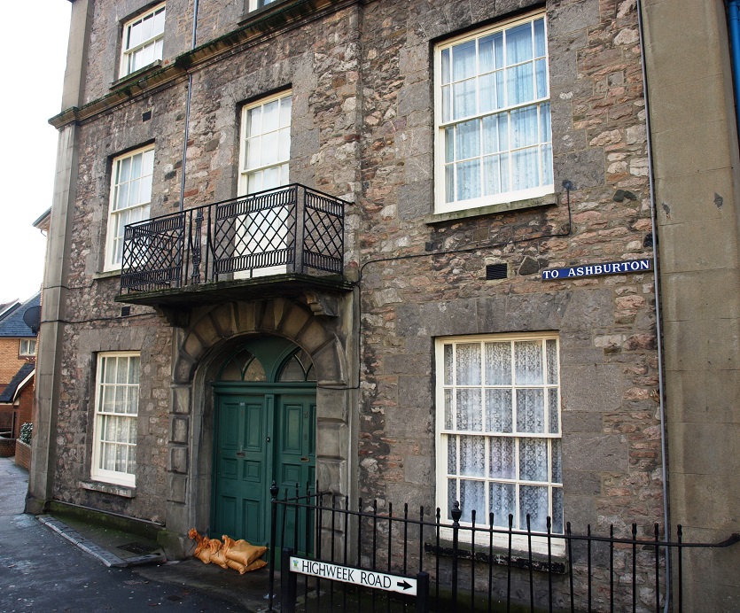 Nos 1 and 3 Highweek Road (January 2014)
On the other side of the road is St Mary’s church with its 15th century tower and early 19th century church hall, now deconsecrated and converted into apartments.
 St Mary’s church and church hall, Highweek Road (January 2014)
Now Highweek Road doesn’t even go as far as Highweek, being cut off at its junction with Wain Lane, to make way for the modern Ashburton Road.
 Highweek Road, looking towards the town centre (January 2014)
The Wolborough settlement, by then owned by Torre Abbey, was granted a charter to hold a weekly market in 1220, and Teignweek obtained a similar charter in 1246. Wolborough also has a church on a hill – St Mary’s – which dates from the fifteenth century. Presumably the rationale for placing churches on hilltops was to make them very visible and ever-present to the local community, but it can’t have been pleasant for members of the congregation to have to trudge up and down steep hills to attend services, especially in wind and rain with no shelter.
 Part of the graveyard at Wolborough church. (September 2012) Below the graveyard, on the other side of the road, are buildings of Wolborough Barton Farm
 The grassy slopes of Wolborough Hill close to the church (September 2012). Highweek church can just be seen on the horizon in the distance, about a mile away. There are plans for a lot of new house building in and around Newton Abbot, with no less than 1,500 new houses earmarked for Wolborough, so it is only a matter of time before these slopes are covered by a further extension to the built up area of the town.
The 17th century Forde House (now called Old Forde House as Teignmouth District Council cheekily named their nearby modern offices Forde House) is located in the southeast corner of the town and was built in 1610 for Sir Richard and Lady Lucy Reynell.
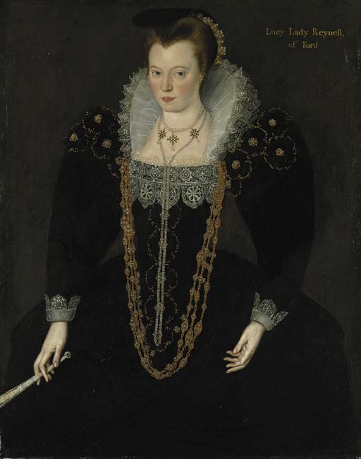
Portrait of Lady Lucy Reynell. (This painting is at East Ogwell House.)
Forde House had an ‘E’ shaped floor plan in honour of Queen Elizabeth I, who had recently died. The house was originally named after hamlets which stood where the roads to St Marychurch and Combeinteignhead crossed the Aller Brook at a fording place. The Aller Brook here used to meander through meadows and there was a separate leat flowing through the grounds of Forde House – now it has been straightened and contained and the A380 occupies the meadows. As you would expect, the House used to sit in large grounds, including a deer park and the area known as Decoy, where wildfowl used to be caught. In 1625 King Charles I stayed at the house on his way to and from inspecting the fleet at Plymouth, during which time an elaborate feast was held in his honour, in exchange for which he knighted the owner and his brother. In 1648 Oliver Cromwell and Colonel Fairfax took shelter there on their way to besiege Dartmouth, then held by Royalists. Supposedly, the mansion saw a lot of action in the Civil War, changing hands a total of six times.
Old Forde House is now owned by Teignbridge District Council and is used as offices and for conferences, weddings and other events.
 Old Forde House (August 2013)
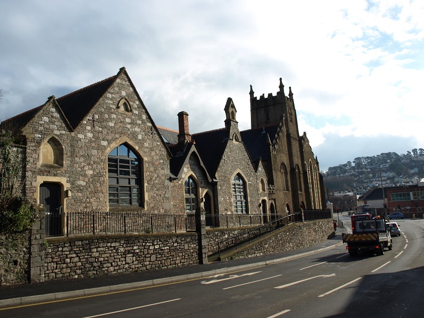
The ancient tower of St. Leonard is prominently positioned at one end of the main shopping street. The tower is all that remains of the medieval chapel of St. Leonard, which was founded in 1220.
The profile of the roof of the attached chapel, demolished in 1836, is clearly visible on the tower. (February 2012)
As well as the chapel, market buildings and a slaughterhouse were also situated in the middle of Wolborough Street, which must have been unpleasant for nearby residents. In 1825 the buildings were removed and the market relocated.
There is an illustration of what this area looked like in medieval times on an information notice located next to the tower.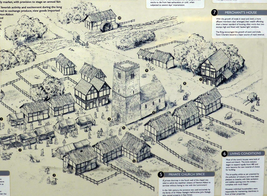
Adjacent to the tower is a plaque marking the spot where the first declaration of the newly arrived William III, Prince of Orange was read in November 1688. William had arrived in Brixham on the 5th, and reached Newton Abbot on the 6th (not the 5th as it says on the plaque), when he stayed overnight at Forde House with the upper echelons of his entourage and bodyguards before going on to London to assume the English Throne. Forde House was then owned by Sir William Courtenay, who diplomatically invented urgent business elsewhere, to avoid associating himself with what might have been a failed revolution. William of Orange’s army, estimated at 30,000 men, camped overnight on Milber Down.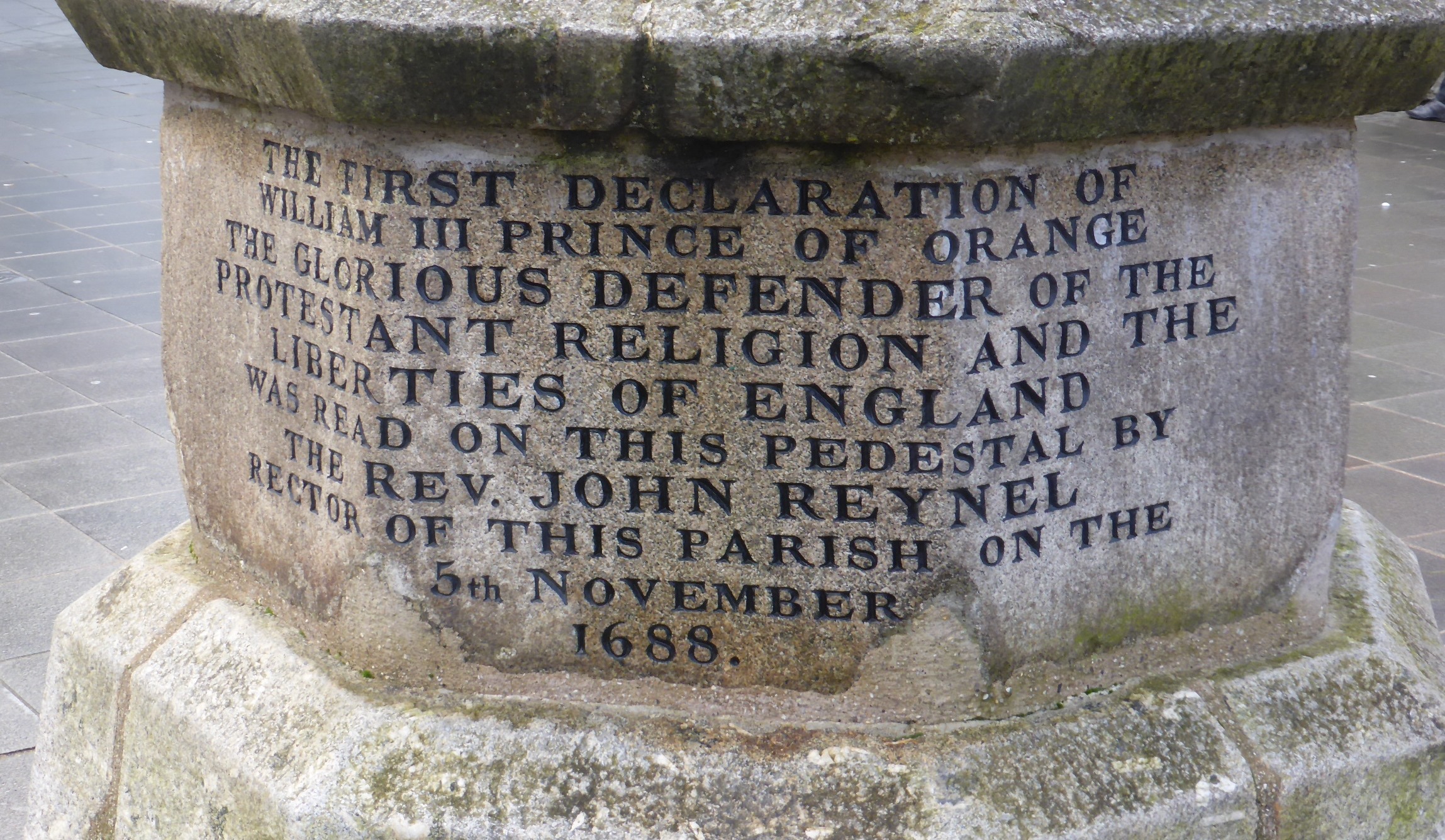
The Courtenays had acquired Forde House and the extensive Wolborough estates through the marriage, probably in 1648, of William Courtenay to Margaret, the daughter of William Waller and his wife Jane née Reynell. The Courtenays family moved from Forde House to Powderham in 1740, after which it was let to relatives and a series of tenants until finally sold in 1936.
In the 1840s they supported the routing of the railway along the coast past Powderham Castle and into Newton Abbot, which otherwise might have been by-passed by an inland route between Exeter and Plymouth. There was of course considerable financial advantage in so doing, since it had the effect of increasing the development value of the Courtenay’s landholdings in Wolborough.
A new chapel, larger than the old one, was built a little way along Wolborough Street. Until recently it was a second hand furniture and antiques saleroom, but is now (September 2016) empty, although it was reported in July 2016 that it had been bought by Newton Abbot Town Council for conversion into offices and a community hub.
 St Leonard’s chapel (January 2014)
 The buildings next to the tower on the left above are probably the oldest survivors in Wolborough Street. (January 2014). The one on the corner, of what used to be one of the main junctions in the town, was once a courthouse. A restaurant that occupies the upper floor of all three houses, has old roof beams and an impressive stone fireplace.
In what’s left of Wolborough Street on the other side of the modern road junction, there is a group of houses whose origins range from the 17th to the 19th century.
 Numbers 81 (right) to 75 (left) Wolborough Street (January 2014)
When built these would have been high status houses, and Wolborough Street a comfortable and convenient place to live, right in the town centre but with only light horse traffic passing on the road towards Totnes. Now it is a narrow road blighted by heavy motor traffic, with vehicles passing within a few feet of front doors, and inevitably some of the buildings are looking rather worse for wear.
 No 83 Wolborough Street. This must have been an impressive house when built around 1840.
 Looking from the southern part of Wolborough Street across the modern road junction, which presumably necessitated the demolition of 40 or 50 houses, to the northern section around St Leonard’s Tower, in the distance. (January 2014)
In 1836 the first direct road from Kingsteignton to Newton Abbot was approved by an Act of Parliament – until then travellers had to go a long way round via Teign Bridge. A new access route into Newton Abbot from the new bridge was also needed, and as a result Courtenay Street was completed in 1842. The construction of this new road disturbed various existing properties including two coach houses and three piggeries.
The Globe Hotel was rebuilt to be aligned with the new road, and with an impressive entrance on to it. The Archduke Nicholas of Russia changed horses at the old Globe in 1828 while on a tour of England. The Duke of Wellington also changed horses at the rebuilt hotel in 1846 – he was a very famous person and crowds gathered to see him. The prominence of the Globe within the town was emphasised when the first batch of telephone numbers was allocated in 1899 – its number was Newton Abbot 1. The hotel closed in 1988 and the building is now occupied by part of Austins department store.
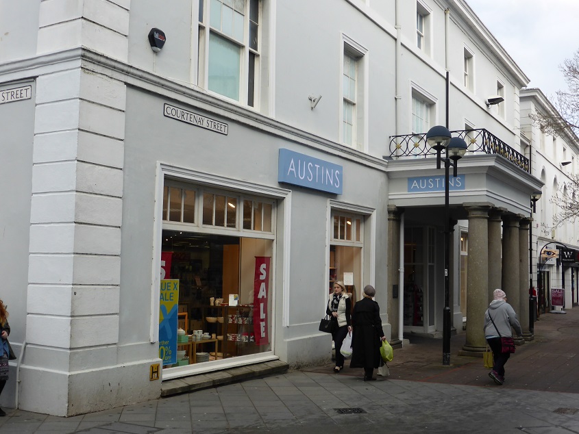 The old Globe Hotel building (January 2014)
Until the railway arrived in 1846 the way to travel for those that could afford it was by coach. There were services to Exeter twice and Torquay six times daily. Six horses drew each coach. Soon after it arrived the railway displaced coaches on the routes it covered, but horses were still used for other routes and for transport to and from railway stations.
There was no existing road going past the site of the new station. Due to various disputes and delays with the special Act of Parliament needed Station Road (which later became Queen St) was only finished the day before the station opened on the last day of 1846.
 Queen Street (January 2014)
The Pharmacy in Queen Street was established in 1877 by chemist John Bibbings and it still retains many of its original features, including the drawers where he stored his potions and remedies and a mosaic he laid down. At beginning of the 20th century he sold his own brand of perfume called ‘Bradley Woods Bouquet’ which was claimed to be rich, lasting and refreshing, and to protect against damage by moths if sprinkled on a handkerchief kept with clothes.
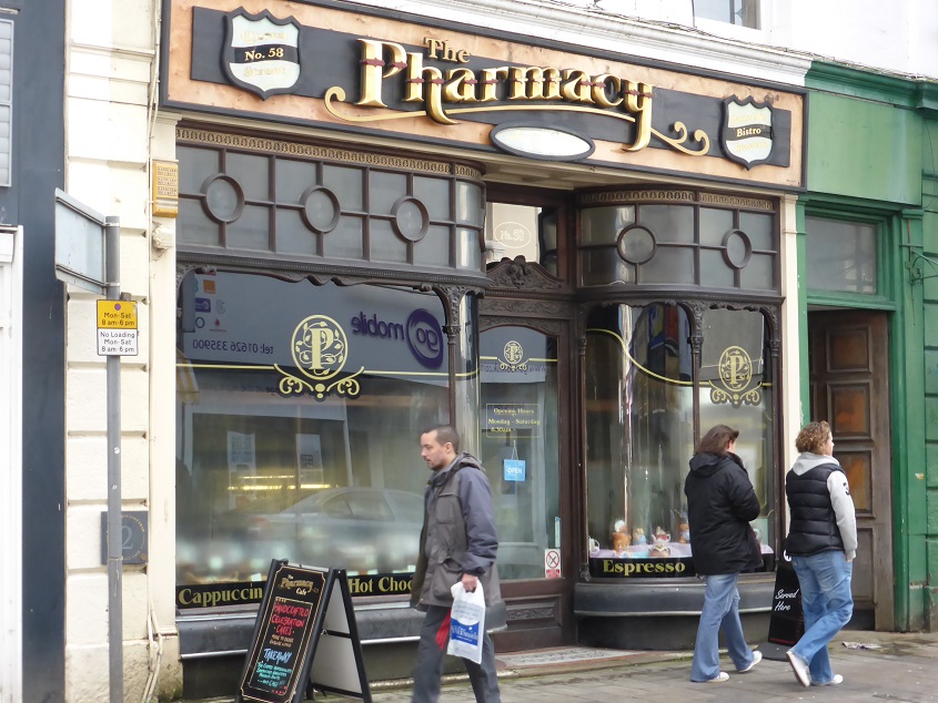 The Pharmacy café (January 2014)
Lloyds Bank began life as Taylors & Lloyds in 1765 and traded from a single office for the next 100 years. The first branch office opened in Oldbury, six miles west of Birmingham, in 1864. The symbol adopted by Taylors and Lloyds was the beehive, representing industry and hard work. The black horse device dates from 1677, when Humphrey Stokes adopted it as sign for his shop. Stokes was a goldsmith and banker and his business became part of Barnett, Hoares & Co. When Lloyds took over that bank in 1884, it retained the black horse as its symbol.
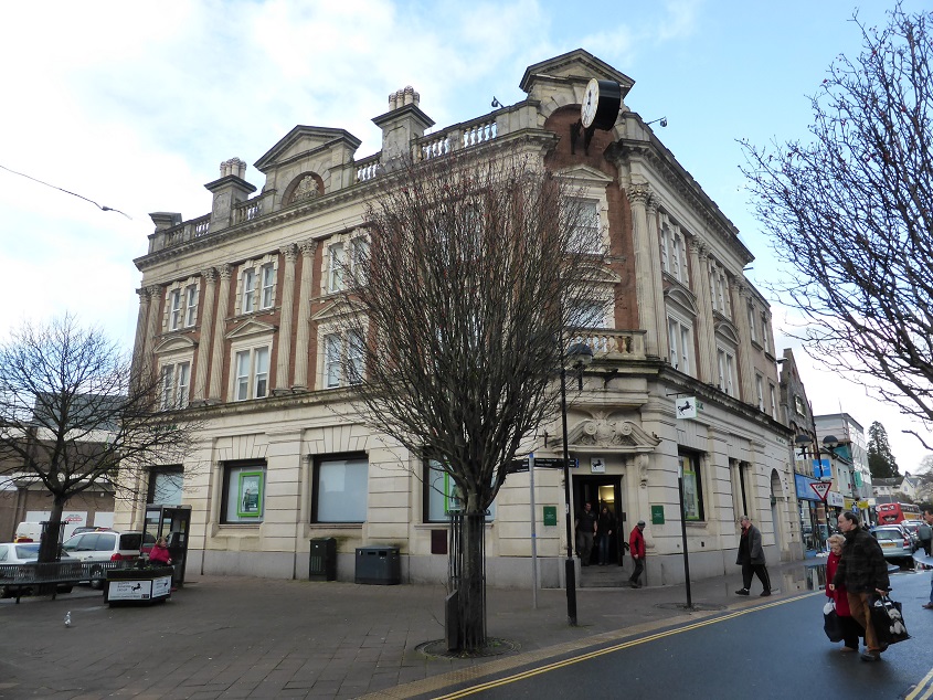 The impressive Lloyds Bank building on the corner of Courtenay St and Queen St. (January 2014)
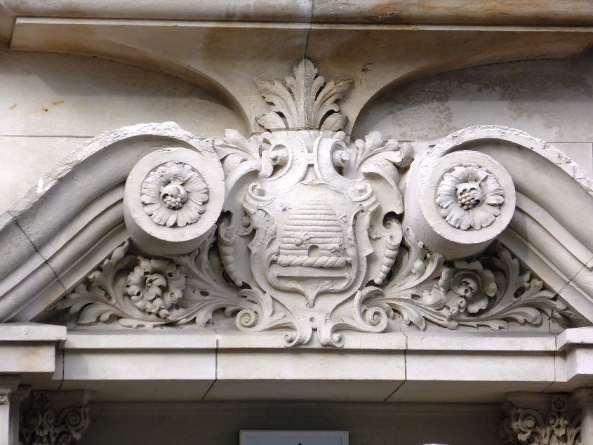 The beehive coat of arms above the entrance to the Lloyds Bank building. This indicates that it was built between 1874 and 1884.
In medieval times there was a lot of sheep rearing in Devon and consequently there were wool, cloth and leather industries in the towns. Newton Abbot had woollen mills, fullers, dyers, spinners, weavers, tailors, tanners, boot and shoe makers, saddlers and glovers, and an important annual cloth fair. Fell mongering – separating the wool from the sheepskin, which was done by hand and presumably was a pretty messy, exhausting business – was a particular specialty, and continued until the Second World War. During the 19th century Vicary’s Mills became an important employer in the town, employing over 400 men in the 1920s; it finally closed in 1972, by which time it was making man-made fibres.
A reminder of a once-successful clothing business can be seen in Courtenay Street.
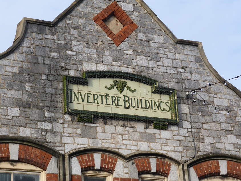 A tiled plaque above a shop at the eastern end of Courtenay Street indicates that this used to be the premises of a tailor called Parkin, who invented a reversible raincoat that he called ‘Invertere’. He sold the patent to Daks Simpson in the 1950s; they had a business making coats and gloves in the town until it closed in 1986. ‘Invertere’ garments were evidently well made, as there is still a demand for second hand examples.
Between 1600 and 1850 many people in Newton Abbot were also engaged in the Newfoundland fishery business, described in the section of this website on Teignmouth. Every year men from the town would gather at the Dartmouth Inn or the Newfoundland Inn in East Street in the hope of being hired for a season’s work.
 The Dartmouth Inn on East Street. (February 2012)
Elsewhere in the town there were workshops making fish hooks, knives, waterproof boots and ropes.
 The Passmore Edwards Public Library (March 2010)
The most impressive building in the town centre is the Passmore Edwards Public Library, which was opened in 1904. John Passmore Edwards was a noted benefactor, having become wealthy from a publishing business which he used to promote world peace and social reform. In all he provided funding for over 70 major buildings including hospitals, libraries, schools, convalescent homes and art galleries. In this case he donated £2,500, in memory of his mother who had been brought up in Newton Abbot. £2,500 is equivalent to about £250,000 today. A further £1,200 was raised from public subscriptions and the council contributed £2,700. (The construction cost was £2,290, so clearly in real terms building costs were much lower in 1904 compared to now.)

Originally the building also housed a science, art and technical school. The architect was Silvanus Trevail, considered the most prominent Cornish architect of the 19th century, who specialised in schools and hotels, including the King Arthur’s Castle at Tintagel and the Carbis Bay at St Ives. The style of the exterior of the Passmore Edwards Library is Renaissance-inspired, with terracotta mouldings over the windows and doorways.
 Details of the façade of the Passmore Edwards Library (February 2012)
Now – in the early 2010s – there are open views of the façade of this building as it sits on the edge of a featureless open space in front of the ugly Asda supermarket. In the area occupied by this open space and the surrounding roads there used to be a warren of narrow streets and alleys, and what used to be the High Street with many inns and public houses was roughly where the traffic-ridden Newfoundland Way is now.
 New Liberal Club building (January 2014)
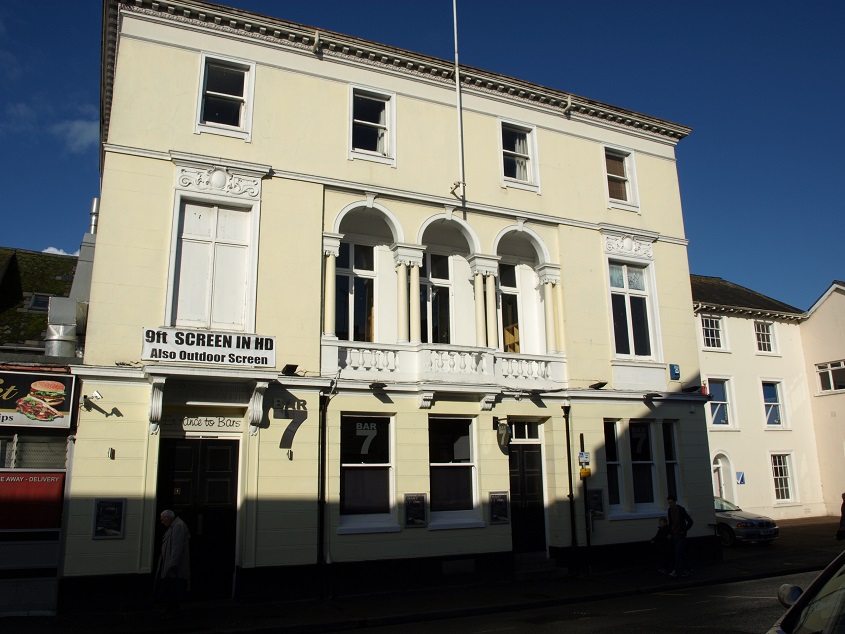
Just round the corner from the Passmore Edwards Library is this elegant building, now a bar, but originally built in 1914 as the New Liberal Club, at a time when the Liberal Party was in government, headed by the Prime Minister Herbert Asquith. Presumably the first floor balcony was included so that newly elected MPs or councillors could address the assembled crowd – given the steady demise of the party from the 1920s one wonders how often that happened.
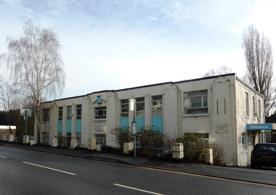
In terms of more modern buildings of interest, Teign House in Kingsteignton Road, built in 1937, has a geometrical art deco design on its façade which, if tidied up and painted in suitable colours of the period, could brighten up an otherwise drab, busy road. But the building is now clearly neglected, and is threatened with demolition to make way for a block of apartments. (Since this was written, in April 2014 the building was demolished.)
 Teign House, Kingsteignton Road (January 2014)
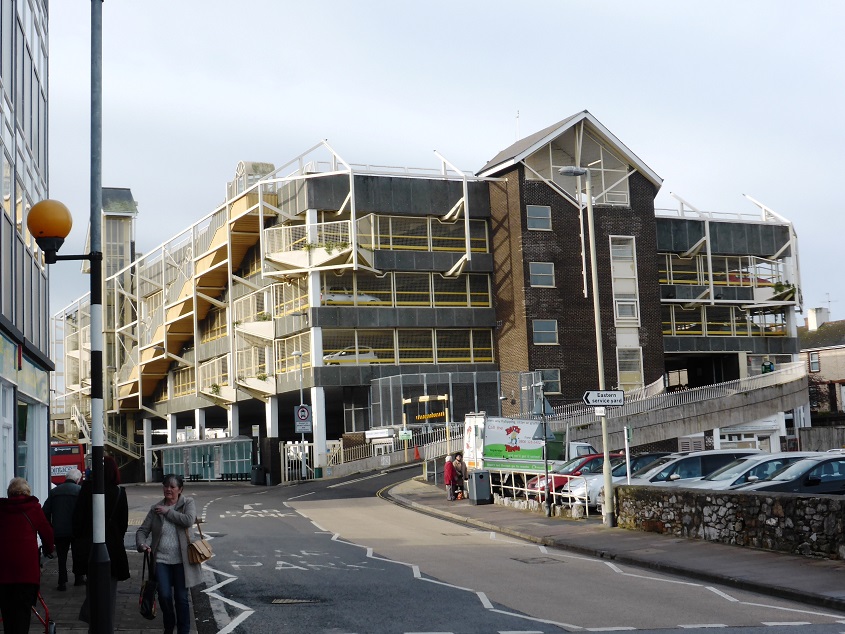
The multi-storey car park on Halcyon Road also deserves attention. Such structures are usually anonymous eyesores, and this one is certainly not a thing of beauty, but it does have some character.
 Multi-storey car park (January 2014)
The above photo was taken very near to Hero Bridge, which is where the Lemon re-appears after flowing in the tunnel under the centre of the town.
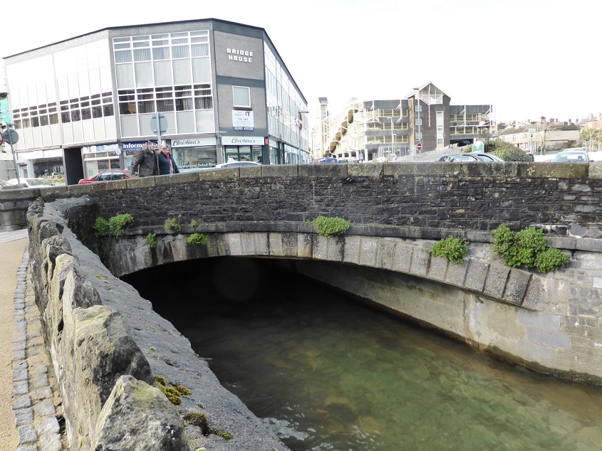 Hero Bridge (January 2014). The origin of its name is uncertain. There may have been a heroic rescue here from the fast flowing water at some time in the past, but the most likely explanation is that it was named after a nearby row of cottages, although of course that begs the question as to the origin of their name.
History books and websites tend to list notable people who have been either born, brought up, lived or worked in the place in question. For Newton Abbot the list includes Frank Matcham (1854-1920), a theatre architect who designed the London Palladium and London Coliseum and many others, and Oliver Heaviside (1850-1925), an electrical engineer, mathematician and physicist who advanced the idea that the Earth’s uppermost atmosphere contained an ionized layer known as the ionosphere and predicted the existence of what later was named the Kennelly–Heaviside layer, including means by which radio signals can be transmitted around the Earth’s curvature.
But, as a film historian, the name that caught my eye was the actress Norah Baring (1905-1985), who was born in Newton Abbot. In spite of a relatively short cinematic career (14 films between 1928 and 1934), she is known for playing the female lead in Anthony Asquith’s innovative silent thriller A Cottage on Dartmoor (1929), and for portraying “Diana Baring” in Murder! (1930), one of Alfred Hitchcock’s early sound pictures. There is renewed interest in films of this era, as many have recently become available again on DVD, some after extensive restoration. Norah Baring’s acting was very naturalistic by the standards of the time, and she might have become a big star if she had not retired so early to raise a family. During World War II, when she was divorced from her second husband, she set up a hostel for evacuated children in South Wales. She wrote a book about it, in particular her difficulties as an Upper Middle Class woman from London in dealing with the working class families and their evacuated kids, not used to niceties like toilets, bedlinen, nightwear and property rights. And she says that the local villagers were scandalised by her going alone to the pub, entertaining male friends at her house – and generally behaving like an actress!

Norah Baring in ‘A Cottage on Dartmoor’
And there is also Dr Ivy Williams, who was born in Newton Abbot and in 1922 became England’s first female barrister. She is one of those depicted in three unusual see-through metal sculptures erected at one end of the new Town Quay Bridge over the Teign. The other two are Isambard Kingdom Brunel, who brought the railway here in 1846, and a clay cutter, representing the local ball clay industry.
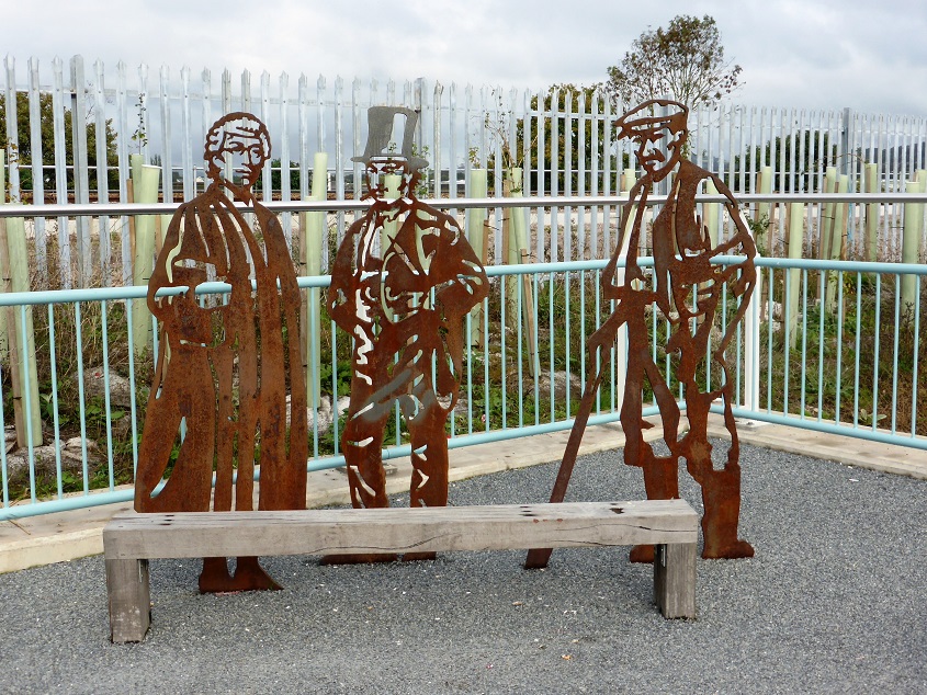 Metal figures on Town Quay Bridge (October 2013)
This attractive bridge, which opened in March 2013, provides a new link for cyclists and pedestrians between Newton Abbot and Kingsteignton. It is 90m long, cost £1.1m to build, and is suspended by cables from a 30m high mast.
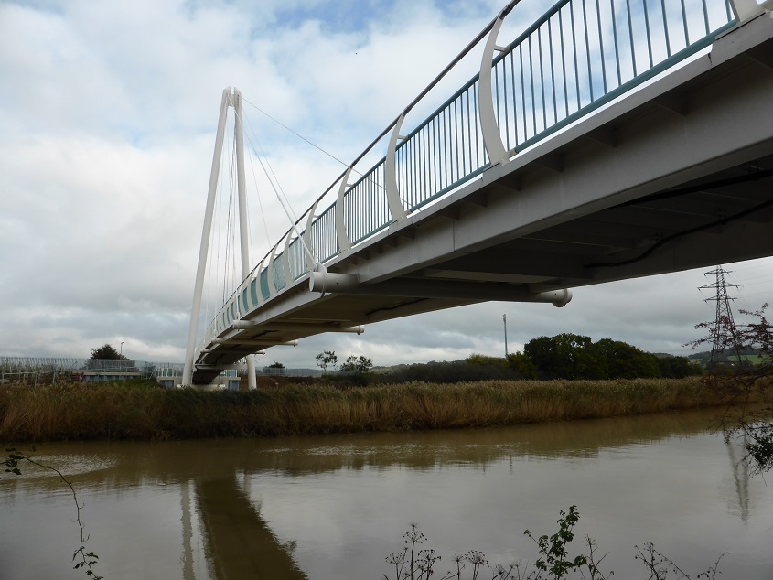 Town Quay Bridge (October 2013)