Introduction
The Bovey is the largest tributuary of the Teign. It has two main source streams, rising within a mile of each other either side of the B3212 Moretonhampstead to Postbridge road, and joining together near Jurston.  East Bovey Head (May 2013). The river rises in a boggy area at the top of the valley on the right.
The juvenile river briefly flows north and then east before it reaches its main south eastern course past North Bovey and along a picturesque wooded valley between Manaton and Lustleigh. The Bovey has two main tributaries. The Becka Brook rises south of Hound Tor and joins the Bovey below Trendlebere Down.  Hound Tor (May 2013) A group of walkers can be seen about to ascend the path to the top.
Woods in the Bovey valley from Trendlebere Down (July 2012)

The Wray Brook starts north of Moretonhampstead and joins the Bovey near Drakeford Bridge, south of Lustleigh. The Bovey continues south east past Bovey Tracey, to join the Teign in the claypits area north west of Kingsteignton – about 13 miles in all.
The Bovey catchment area is bounded on the west by Chagford Common, a watershed across the eastern edge of the moor centred on Hookney Tor, and the road from Fordgate past Hound Tor to Hemsworthy Gate. On the south its boundary with the catchment of the Lemon and Teign runs from Hemsworthy Gate to Haytor Rocks to Brimley and then north of Stover Country Park. Its eastern boundary runs roughly from Chudleigh Knighton to Doccombe, and to the north it extends to just north of Moretonhampstead on a line to Meldon Hill south of Chagford.  On the southern boundary of the Bovey catchment – Haytor Rocks from the south west (May 2013)
 The confluence of the Bovey and the Teign © Robin Stott, January 2010
The western side of the catchment/ the valley above Bovey Tracey
The hamlet of Lettaford is not far from the source of the Bovey, situated at the end of a lane, on the edge of the moor just north of the B3212 west of Moretonhampstead.
 The junction at Furze Park. (May 2013) The lane to Lettaford goes off to the left.
The first impression of Lettaford is of a place frozen in an earlier time. It mainly consists of three farmsteads of medieval origin, each with a longhouse and separate barns and animal buildings, clustered around a small green with a stream running across it.  The green at Lettaford May 2013).
The star building here is Sanders, considered to be one of the best surviving Dartmoor longhouses. It is unusual in that the shippon remained in its original state and was not converted for residential use, so the three main components of a longhouse: the hall, shippon and cross passage between, are still intact. The shippon is where the livestock would be kept during winter and any dairy cows milked in poor weather. Sanders remained in use as a farm worker’s house virtually unaltered for almost a century up to the early 1970s.
In 1972 The Devon Historical Buildings Trust acquired the property, but they realised that restoration would be beyond their means and in 1976 it was sold on to the Landmark Trust, who undertook a thorough restoration and now make it available for rent as holiday accommodation.
The history of this property has been studied in detail, particularly when structural elements were revealed for examination during the 1970s restoration. It was concluded that Sanders was built in the early 1500s with various additions in the mid-1500s and 1600s. The original plan of the house consisted of a single storey with just a shippon, cross passage, hall and inner room. The inner room had a chamber above it which was jettied into the open hall where there was an open hearth. In its early stages it is probable that there was no dividing partition between the cross passage and the shippon, although there was a low one between the passage and the hall. In those days rural folk didn’t expect to be separated from their animals, on which they were dependent, and presumably were oblivious to the powerful smells. The house was built on a slope to enable the muck from the shippon to drain away from the hall.
 Sanders longhouse at Lettaford (May 2013). The high quality granite ashlar construction of some of the remaining walls indicates that this was originally a high status building before its long period of decline. Many more details of its history and the process of restoration can be found on the Landmark Trust website at http://www.landmarktrust.org.uk/our-landmarks/properties/sanders-629
 Thatched barn behind the Sanders longhouse. (May 2013)
Lettaford lies on an ancient trackway that linked the north and south coasts, and now labelled the ‘Mariner’s Way’. Its main track probably ran between Bideford and Dartmouth. The sailors would sign up to a ship and after their spell of duty would be dropped off at, say, one of the north Devon ports. If there was no immediate prospect of picking up another ship on the north coast, they would walk across the county, perhaps in three or four days, in the hope of finding a ship on the other coast.
 A signpost for the Mariners’ Way at Lettaford (May 2013)
 The Mariners’ Way track just north of Lettaford (May 2013)
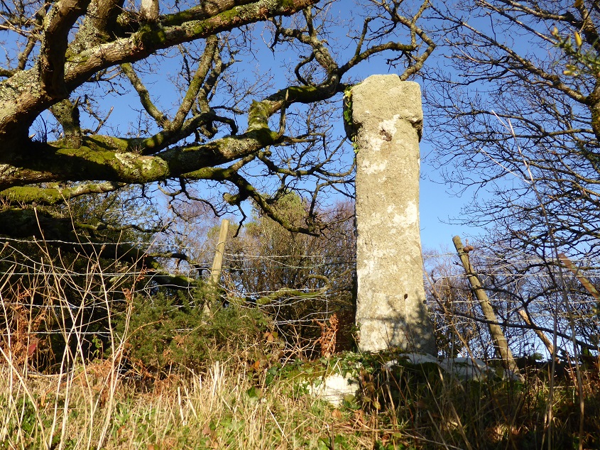
There is an ancient stone cross on the Mariner’s Way not far south of Lettaford, that may have been used as a waymarker. The cross (variously called Leeper, Leapra and Lepra) can be found just off the B3212 on top of the hedge beside the gate on the track leading to Moor Gate Farm.
 Leapra Cross (May 2013)
It might have originally marked a junction of ancient tracks across the moor and, given the size of the remaining cross top, would have had a substantial shaft, perhaps six feet tall. In the early years of the 20th Century, the cross was found built into the garden wall at Moor Gate Farm, which at the time was known as Leeper Farm, hence the name given to the cross. It was moved to the Manor House at North Bovey (now Bovey Castle), by the Lord of the Manor, Viscount Hambledon (son of W.H. Smith of bookshops and railway kiosk fame), but returned to its current position when the manor changed hands in the 1930s.  Stile on the Mariner’s Way near Leapra Cross (May 2013)
There is a more complete and visible cross located at a road junction on the B3212 about a kilometre east of here. Beetor Cross is mounted on top of a wall.
Beetor Cross (December 2014)
Confusingly, on the OS map Beetor Cross(roads) with the lane leading to Beetor Farm, is 100 metres further up the road. The junction where the stone cross is located is known locally as ‘Watching Place’, and the excellent ‘legendarydartmoor.co.uk’ website offers several alternative explanations for this intriguing name: Firstly, it suggests that in medieval times gallows were erected here and relatives or friends of the person hanged would watch and wait for permission from the Lord of the Manor to remove the corpse. Or there is a story that it was where neighbours would place provisions for people who had caught bubonic plague and were isolated in a local house; each day they checked and eventually the food wasn’t collected, whereupon the neighbours called out to confirm that all the people in the house were dead before setting fire to it. Or thirdly, during the Napoleonic Wars French and American prisoners held in Dartmoor Prison were allowed out on parole to stay in local towns and villages but not permitted to go further than one mile from the town. Then Watching Place would have marked the limit for those living in Moretonhampstead – but it’s three miles from the town and seems too far out. I think there may be a more prosaic explanation – it is simply a good location from which to watch out for or meet anyone coming over the open moor from the west – and in the past travel across the moor would have been far slower and more hazardous than today, so there would be relief when the one you were expecting came into view.
Looking up the road towards the moor from Watching Place (December 2014).
From Watching Place a minor road runs south through the attractive western edge of the Bovey catchment down to Hound Tor. The following four photos are examples of what can be seen from the road.
 Barramoor farmhouse (May 2013). Barramoor is a working farm breeding cattle and sheep.
 A field gate opposite the entrance to Easdon Farm. (May 2013) Hameldown Tor on the open moor is on the horizon, about 3km away.
 Cottages, posts of a gate that used to be across the road, and an overgrown phone box at Fordgate (May 2013)
 The road at Swine Down, with the rock outcrops of Hound Tor in the distance. (May 2013)
Going back to the course of the river, the first place encountered is North Bovey. The village is set on a hill well above the river.
 A long bridge and causeway across the Bovey and an adjacent mill stream just below North Bovey village (July 2012)
These lush grazing fields are located between the river and the village (July 2012) 
The village is centred on a large green, surrounded mainly by late medieval houses, an ancient thatched inn (The Ring Of Bells) and the church, which dates from the 13th century. Cross on the village green, North Bovey (July 2012). It was found in the early 19th century serving as a footbridge over a nearby stream, from where it was removed and placed here onto the base of another (lost) cross. That’s a maypole in the background, used during the annual village fair.
 Cottages next to the village green (July 2012).
 Looking towards the church from the village green, North Bovey (July 2012)
About a mile downstream from North Bovey the river passes under this small road bridge, built in 1845, labelled as ‘Clapper Bridge’ on the map.
 ‘Clapper Bridge’ over the river Bovey between North Bovey and Hunter Tor (May 2013)
There is no clapper bridge here now, although perhaps the remains can be seen in this photo taken just a few yards downstream of the road bridge.
Soon after Clapper Bridge the river flows through a steep wooded valley for about 4km, best seen from the various footpaths through the woods and along the river. The woods can also be viewed from a distance from Trendlebere Down.
 Houndtor Wood and Hisley Wood, from Trendlebere Down car park (July 2012)
The road that crosses Trendlbere Down also provides views of Yarner Wood 
… and turning towards the north from the same spot, of Lustleigh in the distance, with more of the Bovey valley woods in the foreground. (May 2013) 
The village of Manaton is west of the valley, between Trendlebere and North Bovey. From medieval times up to the end of the 19th century local people here, and in many other places in Devon, were engaged in tin and copper mining. The mines in both Devon and Cornwall were severely impacted by the discovery of large amounts of good quality ores in the New World and in Australia and most then closed. Many miners emigrated to work these new finds.
 The green at Manaton. The old fashioned street lamp was erected to commemorate the coronation of King George V in 1911.
 St Winifred’s church, Manaton (July 2012)
The church has an unusual dedication. St Winifred lived in Wales in the 7th century and was brought up as a devout Christian. A suitor who was not a Christian proposed marriage but when she rejected him he seriously wounded her with his sword. Then the legend is that where her blood spilled onto the ground a spring welled up – at Holywell in Flintshire. She recovered from her wounds to found a community of religious women of which she became the Abbess, and spent the rest of her life in religious devotion. There is a shrine to her in Shrewsbury Abbey.
Like several other medieval churches in the Teign catchment area, St Winifred’s has a fine wooden roodscreen dating from about 1500 but badly damaged, probably in 1548, when an order went out to destroy all superstitious images in English churches. All the faces from the relief carvings of saints were gouged away. It was cleaned and conserved in the early 1980s.
The main body of the church is thought to be 15th century. Three of the six bells in the tower are very old – markings on the oldest indicate a date of around 1440-50, so it is possible it was originally installed elsewhere before the tower was built. The bells are still rung regularly.

The roodscreen in Manaton church, depicting Christian saints and martyrs (July 2012)
 Looking south from Manaton churchyard, with tors on Hayne Down on the horizon (July 2012)
 These semi-detached 17th century cottages are at Freeland, just south of Manaton (May 2013)
Bovey Tracey
 Bovey Tracey main street (August 2013)
The town centre of Bovey Tracey is situated on rising ground next to the river Bovey – a favourable site, not subject to seasonal flooding but with a reliable year round water source. Apparently there is evidence for a Saxon settlement known as Boffa, named after the river, from about 500AD. In the Domesday Book the settlement was recorded as ‘Bovi’. The ‘Tracey’ suffix was added in early medieval times, from the de Tracey family who became lords of the manor following the Norman Conquest, and who originated from a place called Traci near Bayeux. The combined name first appeared in documents as ‘Bovitracy’ in 1309.
 Another view of Fore Street, Bovey Tracey. (April 2012) The De Tracey Arms pub is next to the bank.
Historical summaries of Bovey Tracey always mention that William de Tracey was one of the knights who in 1170 notoriously murdered Thomas à Becket, the Archbishop of Canterbury, apparently at the instigation of King Henry II. There is now a shrine to Becket at the site of the murder in the north-west transept of Canterbury Cathedral.
 Two elements of the shrine to St Thomas a Becket in Canterbury Cathedral (June 2013)
His posthumous veneration made the cathedral a place of pilgrimage. Becket’s shrine was considered to be a place of healing and the income from pilgrims brought in considerable revenue, which in turn funded the building of a much bigger cathedral to accommodate the visitors.
Becket was originally buried in the crypt but later a highly elaborate shrine, which became encrusted with gold and silver and precious gemstones, was installed in the main cathedral.
 An artist’s impression of the medieval shrine to St Thomas (© Cathedral Enterprises Ltd)
This shrine was confiscated and broken up in 1538 on the orders of King Henry VIII; today a candle burns where it was situated.
 The candle with an eternal flame set on the site of the original shrine (June 2013)
Following his involvement in the Archbishop’s assassination, William de Tracey was ex-communicated by the Pope and, even after trying to make amends by funding various religious buildings, he was required to live in exile. Even before his exile, as an important knight of the realm with several other landholdings in England and France, he is unlikely to have spent much, if any, time in Bovey, which in his lifetime would have been an insignificant country village.
His descendant Henry de Tracey created a borough here in the early 13th century and in 1259 was granted the right to hold a weekly market and an annual three-day fair. He is said to have lived in the Manor House, in East Street, built about 1200. The current Manor House in East St, presumably not on the same site, is a Grade II listed building, judged to be late medieval in origin, with some remodelling and extensions in the early or mid 19th century.
 The Manor House, East Street, Bovey Tracey (April 2012)
The parish church, at the top of East Street, is dedicated to St. Peter, St. Paul and St. Thomas of Canterbury (St Thomas being the same person as Thomas a Becket.) and dates from the 14th and 15th centuries.
 Approaching the church, at the top of East Street (April 2012)
It is set on an imposing site above the town centre. It is known that the first (mud and wattle) church, of the Saxon settlement, was built on the same site.
 Bovey Tracey church (April 2012)
The thatched building nearby dates from 1490; it has served as a church hall, but also as an alehouse.
 The old alehouse (April 2012)
Bovey Heath, to the south of the town, was the site of a battle in January 1646 during the Civil War, in which Cromwell’s troops defeated the Royalist forces of Lord Wentworth.
 Plaque commemorating the Civil War battle on Bovey Heath (August 2013)
The name of the Cromwell Arms pub in the town was presumably inspired by this Civil War connection.  The Cromwell Arms, Bovey Tracey (April 2012)
At the time of the battle the heath was at least ten times larger than it is today. In the interim much of it was damaged by open cast mining for ball clay, and then more recently housing estate and an extensive industrial estate were built on all but the northern end.  Industrial units and office buildings come right up to the boundary of the Bovey Heath nature reserve (August 2013)
What remained was then neglected, being used as a waste dump and for vehicle ‘off-roading’. Things began to improve when it was designated as an SSSI in 1989 and later, in 2002, as a Nature Reserve.  The entrance gate to Bovey Heath (August 2013). The approach to the Nature Reserve is unprepossessing, down a rough lane between a car park and an office building, with much litter in evidence.
Back in the town, the restored Riverside Mill building is now a gallery and café, run by the Devon Guild of Craftsmen.  The Riverside Mill (April 2012)
In fact, the building was never used as a mill, but was built in 1850 as a stable. The prominent waterwheel simply collected water from the river for use in the stables and nearby Bridge House, which is now the Riverside Hotel.
 The river from Bovey Bridge (April 2012)
The old Market Cross, close to the Town Hall, has been restored as a War Memorial. The Market Cross (April 2012)
This was the original site of the village green and the Town Hall was opened here in 1866.
 Bovey Tracey Town Hall (April 2012)

The railway linking Newton Abbot to Bovey Tracey was built in 1866 and closed to passengers in 1959. but goods trains continued to operate until 1970. The track at Heathfield was removed only within the last few years, perhaps to convert it into a cycleway.  The line of the railway at Heathfield (April 2012)
The slots where the sleepers used to be can be clearly seen.
The old railway station building now houses the town’s Heritage Trust. (May 2013) 
Parke, which houses the HQ of Dartmoor National Park Authority, is about a mile out of Bovey Tracey. The mansion that now serves as offices was built for the Hole family in the 1820s, on the site of a Tudor house that they had demolished.
 Parke House (August 2013)
The river Bovey flows through the parkland around the house, which is owned by the National Trust.
 Bridge over the Bovey at Parke (May 2013)
 The river flowing under the bridge (May 2013)
 A lush meadow next to the river at Parke (May 2013)
Below Bovey Tracey the river flows through low lying farmland and then, south of the A38, the northern part of the clay pits area (see the Clay and Canal page in this website)
 The river near Little Bovey Farm, with what looks like the remains of a launching ramp in the foreground (April 2012)
The tributaries
We should now have a look at the two main tributaries of the Bovey. The Becka Brook rises near Harefoot Cross east of Widecombe and takes a course NNE as far as Beckaford Bridge where it turns to the east and flows through Becky Falls Woodland Park and then Houndtor Wood to join the Bovey at Hisley Wood. (Of course the Becky Falls were originally the Becka Falls, but the falls are now part of a privately owned tourist attraction, and presumably ‘Becky’ sounds more attractive.)
 The Becky Falls © Nigel Cox, 2007
As noted above, the Wray Brook rises north of Moretonhampstead and flows below the town to the east. (Moretonhampstead itself is included here in the Teign Gorge page.) Then it follows a south easterly course (as does the A382) for about 5km before turning south towards Lustleigh.
 Road bridge over the dismantled track of the Newton Abbot to Moretonhampstead railway, at Wray Barton (May 2013)
 On the road from Wray Barton to Barnecourt. (May 2013) This could be almost anywhere in the Teign catchment, which is covered by a dense network of minor roads and lanes like this – twisty, up and down, narrow with only occasional passing places, and often bordered by high banks or hedges.
 The A382 south of Wray Barton; here the brook is just to the left of the road. (May 2013)
And continuing further south along the valley … Sheep grazing next to the A382, with Wrayland Barn in the middle distance. (May 2013)
Which brings us to Lustleigh. The village centre around the church is particularly attractive, with a background of wooded hills. Lustleigh can really be said to be nestling in its surroundings. The cluster of thatched houses in the nearby area known as Wreyland is also picturesque.
 The village green with Celtic Cross (May 2013)
 St John The Baptist church, Lustleigh (May 2013)
The oldest parts of the church were built around 1250, with later additions in the 14th and 15th centuries.
 Bell ropes in the tower, Lustleigh church (May 2013)
As with several other local village churches, the oval shape of the churchyard suggests that a Romano-British burial ground may have first occupied this site.
 The churchyard (May 2013)
At Lusteigh this is supported by the presence of a sculptured burial stone dating from around AD 550-600. Presumably it was found when the church was being constructed, because it was built into the floor of the 13th century south porch, where it remained until 1979, when it was lifted and moved inside the church to avoid further wear. The Latin inscription translates as “The stone of Datuidoc the son of Conhinoc” – these must have been men of local importance 1,600 years ago.
 Datuidoc’s Stone (May 2013)
The May Day celebrations are a significant event in the village, involving a carnival procession, maypole dancing, and crowning of the May Queen. The May Day tradition had lapsed until it was revived in 1905 by local author and celebrity Cecil Torr, who lived in Wreyland.
 Wreyland Manor (May 2013)
The May Day Queen and attendants in front ot Wreyland Manor, 1922 (from a postcard sold by The Lustleigh Society) 
Among other things, Cecil Torr wrote two popular books about everyday life in the village in the period before the First Word War, in an unusual style which included his musings, anecdotes and reminiscences. After the 1939-45 war the celebrations were revived again in 1954 and the location of the crowning moved to the Town Orchard, where the May Queen’s throne was erected on a rock which now has the names of all the May Queens from 1954 inscribed on it. To mark the Millenium a new throne was introduced, made from granite from a local quarry.
 The names of past May Queens inscribed on the granite outcrop in The Orchard. The throne can be seen at top left. (May 2013)
 The Town Orchard, with the throne stone in the middle distance (May 2013)
 The May Queen procession, headed by Okehampton Brass Band and followed by several dozen villagers. (May 2014).
 Mummers performing in Lustleigh village square on May Day.
The Wray Brook runs just below the village centre. The Wray Brook flowing under the railway bridge in Lustleigh (May 2013)
Lustleigh Station was on the Moretonhampstead and South Devon Railway, which opened in 1866. The railway brought in summer tourists and was used to export farm produce and nursery plants, but its use declined from the 1930s on. It was closed to passengers in 1959, and then finally to freight in 1964. The village pub, named The Cleave after a local beauty spot, was converted from a farmhouse to a hotel with the coming of the railway.
 The Cleave public house (May 2013).
 An impressive (disused) railway bridge south of Lustleigh (May 2013). This gives an indication of the huge investment involved in building a railway line in hilly terrain.
After Lustleigh the Wray Brook continues south to join the Bovey near Drakeford Bridge.
 Drakeford Bridge (May 2013)

The bridge has a charming inscription on a stone built into one of its walls:
THIS 1684/ BRIDG WAS/ REPARD/ BY THE/ COVNTY
The repair ( and widening) took place in 1809.
The much-photographed Hisley Bridge is situated upstream of Drakeford Bridge, after a section of the river that flows in a steep valley between Hisley Wood and Pullabrook Wood.
This is usually described as a packhorse bridge, with its low parapets to allow for the packsaddles and crooks (W-shaped supporting frames over the saddle) which were suspended from the horses. Of course the bridge would also have been used by horse riders, livestock drovers and pedestrians. It is noticeable how much stonework there is on the approaches to the bridge, which needed to be reinforced to protect the bridge at times of flood. 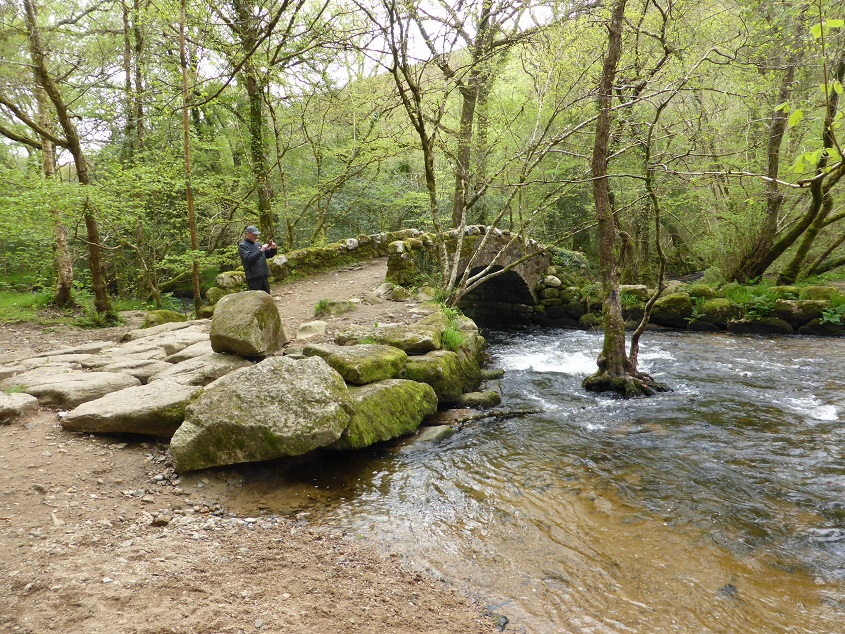 Reinforcing rock platform at the approach to Hisley Bridge (May 2014)
Right next to the bridge is a ford, which would have been used before the bridge was built, when the river flow was low. As with many fording places, it appears that the river bed was artificially widened to reduce the depth of water.
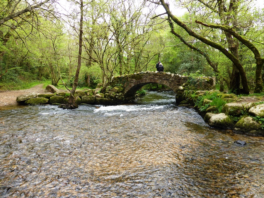 The ford upstream from Hisley Bridge (May 2014)